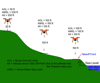
To enable displaying of AGL height over changing terrain, for this function to work correctly for NLD GO 4.1.22 - you will need to do a couple of things:
- Go to https://urs.earthdata.nasa.gov/ and sign up for an account
- Go to http://dwtkns.com/srtm30m/ and download up to 4 "tiles" for your flying area and save them to your device you use with GO
- Install NLD GO 4.1.22. You will need to copy these "tiles" to a your device in the DJI\srtm_data folder. Leave them zipped, so they would look like N21W172.SRTMGL1.hgt.zip and so on.
- Copy and paste the names of these files into a .json file installed on your device. (Due to the different data sets, we can't do this for your area) Go to DJI\og_settings and edit the dtm.settings.json file. This will be easier to do on your PC. Open this file with the editor of your choice, or you can use Notepad. It will look like this:
{"m_AlgoChoice":3,"m_AlgoParams":[30.0,5.0,15.0,3.0,50.0,20.0,3500.0],"m_AltitudeOffset":0.0,"m_DTM_tiles_paths":["/mnt/sdcard/DJI/srtm_data/N21W158.SRTMGL1.hgt.zip","/mnt/sdcard/DJI/srtm_data /N21W159.SRTMGL1.hgt.zip"],"m_DoLogging":false}
- Replace the names of the files currently in RED with the names of your files (“tiles”). Only replace the names of the two that are there and leave the rest of the text alone. So for my example, I will only have one to replace, so the result after editing will be:
{"m_AlgoChoice":3,"m_AlgoParams":[30.0,5.0,15.0,3.0,50.0,20.0,3500.0],"m_AltitudeOffset":0.0,"m_DTM_tiles_paths":["/mnt/sdcard/DJI/srtm_data/N21W172.SRTMGL1.hgt.zip"],"m_DoLogging":false}
- Save your changes and transfer back to your device, replacing the one that is currently there. (DJI\og_settings\dtm_settings.json) Keep a backup of the original. All you want to do is replace N21W158.SRTMGL1.hgt.zip and or N21W159.SRTMGL1.hgt.zip with the name of your tiles for your area. Make changes to this file as you fly in different areas that need different tiles. Check the map here: http://dwtkns.com/srtm30m/ You can have up to 4 tiles listed at a time in this file.
Galileo satellite support built into this version of GO will be implemented soon!! (in the mean time, this would be all you do to get it working, once we turn it on)
Install NLD GO 4.1.22. Allow NLD GO to have a data connection for a short while before or at the field with your bird connected. This allows the sat info to be downloaded quicker into GO and transferred to your bird. You only need to do this once for the initial download. Thats it! Enjoy!
`Quad808 and the rest of the NLD crew

